


Continuing from the first part of our Tour Aotearoa cycle trip from Cape Reinga. We headed out of Auckland towards the Botanical Gardens where I had planned to spend the morning. On the way we went through the beautiful Totara Park which was busy with mountain bikers who were dressed in ‘All the Gear’ and gave us a funny look as we set off along the trails, panniers bouncing away merrily.

The Botanical Gardens had a very impressive entrance which the gardens themselves did not live up to. A big disappointment! I had been really looking forward to this. In this wonderful climate surely the gardens should have been superb. So we set off again earlier than planned towards the coast on our first, but unfortunately not our last, absolutely terrifying road cycle in New Zealand. Generally, world wide, drivers only behave one way when confronted by a long, dead straight road. They drive flat out and don’t consider it necessary to pull out or slow down for anything or anybody. They were coming past us with about 6 inches to spare and I cycled the whole way with one eye on my rear view mirror, ready to leap into the hedge.


The next day, being Sunday, we were off early in the hope of getting the road bit out of the way before the drivers woke up and put their hangovers behind a wheel. We soon turned off onto the winding tracks of the coastal nature reserve where the wind alternated between a head, cross and tail wind. But it didn’t matter as it was amazing and we stopped so often to watch the birds. One side of the trail seemed to be low mangrove swamp then sea and the other cows grazing on lush flood plains and as assortment of wading birds and small ground nesting birds. We also had wonderful views of the Coromandel Peninsula shrouded in clouds and rain in some parts.


That night there was the most almighty thunderstorm with heavy rain which cleared away much of the humidity of the last few days. What was not so good was that our lovely northerly tailwind of the last 12 days suddenly switched to a southerly headwind. It should have been an easy day with gentle climbs on nice cycle tracks across green diary farms but for some reason my legs just didn’t want to put in the miles and it all seemed a bit of a struggle. We were heading into main tourist land at Matamata or in other words Hobbiton where much of Lord of the Rings was filmed. One look at the town and you could see they were really milking it. A bit grim.


We were going to be a bit off grid for the next few days so trying to ignore the Hobbit House we scurried around town stocking up on food supplies and trying to find a light pair of shoes for the canoe section that was coming up. Because of all the rain New Zealand has had recently part of the forest trails to the Bridge to Nowhere is shut. We didn’t want to go on the main road around this part so we decided to spend three days canoeing down the Whanganui River, with the canoe rental company bringing our bikes around to the other end. With all our new supplies squeezed into the panniers we set of to find our B&B which really made me laugh when we found it. It was like stepping into the set of “Keeping Up Appearances” with Hyacinth Bucket (pronounced Bouquet!) a dated 1970’s UK comedy about a woman putting on airs and graces. We could see they didn’t want our panniers to touch anything in their immaculate house.

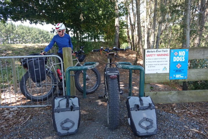
After a hectic dash along a couple of busy highways we arrived at the wonderful Waikato River Trail. The trail itself was very pretty and wound sharply and steeply in places alongside the river and through woodland. It was also very narrow with a steep drop off on the riverside. Tracks like this always make me nervous. I can cycle in a perfectly straight line when its wide but as soon as it gets narrow I wobble all over the place. Then we climbed steeply up to the Arapuni Dam and Power house, famous for being camouflaged during the war so the Japanese wouldn’t bomb it.


We were having a short day and had booked into the Arapuni Backpackers which turned out to be much nicer and smaller than I expected. We chatted with the owners while eating walnuts from their garden and were told to help ourselves to any of the vegetables we found in their well tended garden for our supper. Then after dropping off our luggage we raced down the road to the Rhubarb Cafe for a wonderful lunch and some seriously good coffee followed by a nice lazy afternoon.

The following day, as we headed towards Mangakino things got just that bit more challenging as some of the tracks were definitely above my pay grade. In fact they are labelled as Advanced Mountain Bike tracks and not suitable for touring bikes. We soon found out why! There was a short 5 km section first that took us an hour and at the end of which I found my knees were shaking. We could (should!) have baled out there but it seemed a bit pathetic. So we set off down the next, much longer section. The sign at the start said it would take 9 hours to walk, and I quietly wondered how long it would take to push a bike. It started down what looked like a precipice with 37 tight, sharp and steep switchbacks in quick succession. It would have been fun on a mountain bike but we both walked it, even so it was hard to control the heavy, back loaded bikes with our feet sliding from under us.


I managed to sort of ride the next bit while dodging trees and with large fern fronds slapping my face, with a quick succession of steep climbs, drops and sharp bends on narrow single track, all the while with a long drop off to the side if you didn’t stay on the track. It was exhausting and to add to the fun there were five sets of bike gates where we had to unload all our panniers to squeeze the bikes through.


Then, just when we thought the worst was over we came to the long swing bridge followed swiftly by a steep, slippery flight of 108 steps. We had to unload all the panniers again and carry them down, then Bernie carried the bikes down. When we finally crossed the river at Waipapa Dam it was nearly 3 pm and we still had 20 km to go. So, while we sat by the river eating a late lunch we decided to stay on the road from here. This was probably a mistake as the road promptly left the river and headed up and over the steep hills, whereas the track would have followed the river. But we eventually got to Mangakino, exhausted and hot. Despite all that I wouldn’t have missed it for the world. It had been simply stunning in the forest next to the river.


And it was only going to get harder from here as we were heading more into the forests for a few days and there was a thunderstorm forecast which will be interesting with us camping under a tarp.

We set of up, always up, a very quiet road which soon turned into really deep, loose, large stone gravel that even on the fat bikes was a challenge. Then the road just ended and we found ourselves on a rough farm track with grass down the middle and deep muddy ruts down either side. It was just like a Devon lane at home.


But after bumping along for a while we were presented by the sight of a worryingly rustic looking swing bridge. This one didn’t have a solid base, you walked over moving metal mesh that was vaguely attached to the mesh sides. It was quite high so we hoped the supporting cables were better maintained than they looked. A couple of weeks after we crossed the bridge was tested and immediately closed as one of the supporting cables had corroded.

It was very narrow and only one person was allowed to cross at a time. Bernie bravely set off with his bike. There wasn’t really room to walk beside the bike, it was more a case of leaning over the edge, and the handlebars kept on getting caught up in the mesh so it took quite a while. I followed with the bags trying hard not to look down. After 4 or 5 trips we had everything across. Of course we should have looked around the corner before loading the bikes again as there was a really deep gully and we could only get the bikes down and up the other side unloaded.


Before long we reached the Arataki Track that was a little wider and had a really varied surface from stone stream bed, soft sand, gravel and large sharp stones. But it went through a magical tree fern forest with smaller ferns lining the track. And the Jasmine like smell of flowers was intense from the flowering cabbage trees. Although it was much cooler under the overarching canopy of trees and ferns, a drop from 34 C on the road to 21 C here, it was incredibly humid. We could hear a small stream gurgling down the hillside and caught the occasional glimpse of it between the dark stems of the tree ferns.

Then we reached the Centre of North Island! To get to the actual centre we left our track and cycled down a narrow path into the forest dodging trees that looked as if they had hands and fingers. It was quite spooky and I wouldn’t want to be there on my own. We had our lunch there in the cool before heading off towards our campsite.

There were a couple of downhill sections towards the end and we picked up quite a speed as the surface had improved a bit. I saw Bernie stop just ahead with one pannier on the ground but didn’t have much time to react before I found myself in the air doing a triple jump over 3 deep potholes. I just hung on tight and managed to stay upright with both my panniers flying off and landing on the track.

The campsite was empty when we arrived but a couple of trampers and cyclists soon turned up. We had managed to get our tent up and had eaten supper before the rain started. The main thunder clouds had missed us and we could hear them rumbling in the distance. Importantly our tarp was coping well so far.

The following day we cycled through the truly magical native rainforest of the Timber Trail and one of the most wonderful bits of our route. As it was early the mist was still rising from the trees and it was lovely and cool, only 13 degrees C. We were climbing steadily for 17 km up to nearly 1000 m but it was a gentle gradient so we could look around at the moss covered trees and tall tree ferns.


Generally the track was good going up Mt. Pureora but this changed as we started the descent. It got much steeper with deep ruts and loose rocks, sand and mud. Far from the easy descent we had expected it was really hard work having to watch every inch in front of the wheel and zigzag across from side to side. There were also a lot of steep climbs for a section that was meant to be downhill. It was such a fantastic place to be with some amazingly old, massive trees.


We also had to cross at least 4 very long and very high swing bridges. At about 42 km we started another big climb that really took a lot out of me as it was steep and on difficult surfaces. I was just beginning to flag when we reached a sign that said it was the beginning of the Old Tramway for the timber trains that went as far as Ongarue. This was wonderful as it instantly became a steady, slight gradient with cuttings instead of hills but it also got a lot muddier and very rutted. On this track we made it over a second climb with stunning views of the forested hills in the distance. Then we were on the old Train Spiral which circled around over bridges and through a tunnel as a way to get the trains up and down a steep hill.


Before long we were heading into tiny Ongarue, climbing over a fallen tree on the way. We were staying in a B&B where they had offered to make us supper which was great as I was too tired to do anything myself. We had climbed 1234 km in 85 km over some very rough terrain. That evening we found ourselves being served aperitif while sitting under an old walnut tree in a wild garden listening to a Puccini opera, then moving to an old library to be silver served dinner. There were no other guests and in my exhausted state it was all a bit surreal but lovely.


When we got up that morning we still didn’t know how we would be getting out of there. It had been raining heavily overnight so we were expecting to be told it was too dangerous to set off on a 3 day canoe trip but we filled up with a full cooked breakfast just in case.

Then it turned out we were going to canoe after all. No one actually said, it was just sort of understood. So a quick change and we rolled the bikes down to the river landing. There we emptied our panniers into 4 waterproof tubs which were tied into the centre of our 2 man canoe. The canoe company were taking our bikes and panniers around to meet us at the other end.
Feeling very apprehensive a group of 8 total novices circled the canoe hire man to be told how to steer, avoid getting stuck on rocks and fallen trees and how to deal with rapids. I wasn’t reassured by being told they were only grade 1 or 2 rapids. On the final day there would be a difficult rapid called a 50:50. That, apparently, is our chance of tipping over when we inevitably hit the rock in the centre. They didn’t really tell us how to avoid it. He also said that we should get off the river if we were passed by a tree and I thought he was joking!

I felt a bit calmer once we set off. About 15 canoes had left during our briefing and we soon out paced the youngsters who seemed to be going around in circles. So we were on own, wonderfully peaceful between towering cliffs of dense native forest and strangely, the calls of peacocks. Yes Peacocks! No idea how they got here. We did the odd circle ourselves until we got used to the strong eddies, and we zigzagged around as we practiced steering. I was the ‘engine’ at the front and Bernie was steering at the back. He did a very good job and we set up a communication system between lookout and paddling instructions. It was like being back on the tandem.

We had regular mini rapids to keep us alert and there were a lot of fallen trees with long branches reaching out just at water level. We had to stay constantly alert, so between that and my aching arms and shoulders we were very tired at the end of the day. Despite all the terrible weather forecasts we had a pleasant day with only the odd heavy shower and you somehow don’t notice getting wet when you are on the water.
Arriving at the John Coul campsite we were pleased we made it into the landing and didn’t overshoot. The landings are just a patches of mud with no trees so easy to miss on the fast flowing river. We then carried our 4 heavy barrels up the steep, muddy steps to the campsite. Our tent is usually held up by our bikes, we have no poles, so here we fixed one end to a picnic table and the other end to our 2 paddles. I was very pleased with the result and it made the others in the campsite laugh. I think they were taking bets as to whether it would still be standing in the morning.

We just managed to cook supper before the evening deluge started. All the campers squeezed under the shelter until bedtime. You can only access this campsite by boat so there was a mixture of long distance walkers who had also been affected by the closed trail and long distance canoeists.

In the morning as soon as the rain stopped we had a quick breakfast, carried our barrels back down to the river and we were off like old hands. Well, nearly like old hands. There was a lot more water in the river so it was moving faster and the eddies were stronger, spinning us round before we knew it. Once we got the hang of it we found it was actually easier as there were less rapids due to the deeper water.

During the day we saw some Grey Ducks, Kingfishers and some Blue Ducks (Whio) which are now quite rare in New Zealand. My arms and shoulders were really tired so we stopped off twice on the way down, the second time at the Mangapurua landing where we would have been picked up by Jet Boat if the Bridge to Nowhere track had been open to cycle down. We decided against walking up to see the Bridge and to push on to Tieke Kainga where we were stopping for the night as we noticed that the river was still rising fast and was steadily getting too difficult for us novices to manage. I was rapidly realising that when we were told to get off the water if we were passed by a tree it was not a joke, alarmingly it was beginning to happen.

We arrived at Tieke Kainga where there were 2 campsites, one on each side of the river and the Bridge to Nowhere Lodge a bit further along and up high where thankfully we had booked dinner, bed and breakfast. We ended up carrying our heavy barrels up a steep hill then along a slippery muddy track for half a mile in torrential rain. There are no roads here so everything arrives by Jetboat or canoe.

We eventually staggered into the wonderful Lodge dripping wet and covered in mud. It was heaven walking inside and steaming gently in front of their wood burning stove. We were shown to a lovely room with a river view and handed a cup of tea.

After cleaning ourselves up we settled on their comfy settees while all the people we had met at the last campsite slowly squelched in. Most of them are camping tonight but it was raining so hard they hadn’t yet set their tents up. Being by the fire was too inviting. We were sitting there smelling a delicious supper being cooked for us. Just wonderful.

Meanwhile the torrential rain was still coming down and the river level was rising. Before we started eating I mentally marked several trees that seemed a long way up the river bank far below us. When I looked again after supper they had gone. The river had risen over 2 meters in that time and was still rising. I was more than a little worried about canoeing the next day as having spent many years messing about in boats I knew what a dangerous combination water and inexperience was and how fast things could go wrong.

It rained heavily all night and it was so comfy in our lovely dry room and soft bed after camping the previous night. We were woken at 5 am by their cockerel (rooster) who crowed non stop for an hour just under our window. I looked out of the window down towards the now swollen river that must have come at least a meter higher up the bank than it was yesterday. I could see large trees washing down in the flow and big swirling currents. I was terrified at the thought of getting into a canoe on what would have been our most difficult day anyway.

Thankfully the owner of the lodge, Jo (a very decisive character) said that no one was going anywhere in a canoe today. They would get us all out by Jet Boat. I could have hugged him in relief. Apparently the beach where we had tied our canoe was now totally under water. The people in the campsite had spent the morning hauling all the canoes right up the bank. One or two had turned over and been dragged under.

The Lodges problem was that their larger jet boat broke down the previous day and they not only have a full lodge but also a full campsite so the evacuation will taken a while.

We all piled into the now repaired jet boat and squeezed in all the luggage. After a quick safety talk in case he had to do an emergency stop because of floating trees we were off. We had to swerve a lot because of the amount of debris.
We were straight into a lovely gorge with lots of waterfalls gushing right over the river as there was so much water. The driver had to turn the engine off at one point as it had sucked up some debris, which was a bit alarming as we caught in the current for a time. But it started up again luckily.

To avoid all the branches the driver sometimes took us tight into the cliffs which was exciting. Looking at the state and speed of the river I was just thankful we weren’t in the canoe.

Then we arrived at Pipiriki. As the landing stage was underwater we all had to clamber up the bank. I was thankful to be met by the man who had our bikes. We quickly filled up our panniers and peddled up the road. Just wonderful to be back on the bikes, we had enjoyed our time in the canoe but two days was enough. We had booked ourselves into a nearby holiday chalet as we thought we would be tired after paddling. Although we were there early it was still raining so we were glad to stop for the day and just have a lazy afternoon.
It was wonderful to be back on the bikes where we knew we could deal with anything that happened. I had not felt the same way in the canoes as the situation deteriorated.

We had completely run out of food so we stopped in the tiny village of Jerusalem. The shop was shut but we spent sometime looking around the convent and the old church there.

It wasn’t far to the next village of Matahiwi where there is a great cafe. We ate quite a lot, drank copious amounts of coffee and bought some pies for later. We also bought some of the Whanganui Manuka honey. There are literally hundreds of Apiaries also this stretch of river. Manuka honey is very expensive and sells worldwide. So it is not surprising that theft of hives is becoming quite common.
It was a lovely cycle along the river, initially through the native forest and later through farmland. Some of the time the road was narrow and hard up against a cliff that had been dropping rocks during the heavy rain. We passed through Jerusalem, London and Athens; just a few houses in each.
There were only 2 big climbs and after winding up Gentle Annie, the second climb we stopped to admire the view down over the river. There was a German family there having a picnic and they kindly gave us some delicious coffee while we chatted. So Jurgen, Dorothy and Lyvia, if you are reading this, thanks very much, it was really appreciated.
Before long we were in central Whanganui which has it’s fair share of unsilenced cars with the associated inability to drive safely but we soon found our Airbnb where we stayed for two nights and our first day off. We were sharing the first floor of the Old Fire Station with the Darcy Bussel School of Ballet.

We had a lazy morning as it was pouring with rain, then we wandered around the arty area of town visiting galleries, glass studios and a fantastic ceramics museum. Then spent sometime booking ahead all our accommodation until after Christmas as everything is filling up fast. We don’t generally like to book ahead as we can’t vary our distance if we are feeling tired or the weather is bad. We also found the ferry from Wellington to south island was full so we would have to wait a day.
What a great adventure! I bet you had a great time exploring that beautiful place! Stay safe!